
The longest continous hiking route in South America, running across the chilean Andes from the capital Santiago all the way south into Patagonia, just these little facts made me dreaming when I first heard about the Greater Patagonian Trail from my friend Christine, a very experienced hiker, about 3 years ago.
And when I researched a bit about that trail, I found its story very interesting as well:
The german Jan Dudeck did a multiday horse trip with his chilean wife Meylin and tracked the route by his GPS. When he transfered the track to Google Earth, he realized, that the tiny horse trails they followed were visible on the satellite pictures. That brought the idea, to create a long distance trail running the length of Patagonia, mainly by using Google Earth. He added stretches which are located in central Chile, outside of classical Patagonia, therefore he named the trail "Greater Patagonian Trail".
Since he began that great work, he spends every summer in Chile, to scout new segments of the trail and to verify what he saw on Google Earth. The fact that he mapped a lot of alternatives, often still not groundtruthed, make the Greater Patagonian Trail even more interesting.
Originally I had planned to start at the northern Terminus in Radal, but just a month before I started, Jan told me, that now the trail is even extended to the Capital, Santiago de Chile. The last metro station of that city, what an exciting starting point!

Before my plane lands in Santiago, I enjoy beautiful views on the high peaks of the Andes, a first taste of the upcoming hike!
I find an ATM in the airport building and soon hop on a bus to the City. At the Metro Station Pajaritos I leave the Bus and first use the red Line to Tobalaba, before I switch to the blue Metro line. After a long ride I reach the final Station Plaza de Puente Alto, where I can start hiking at about noon.

It doesn't take long before I reach the City limit. At the outskirts of a 6 million people metropolis there are two possibilities: slumlike shantytowns or homes for the rich. The GPT touches rather well heeled areas, which means that the backroads Jan incorporated in his route are private, locked and fenced, so for a long time I need to follow the tarmac.


Some people stop their cars and offer me a ride, nice Chilenos! But as I want to walk, I have to neglect these offers.
Later in the day the route leaves the tarmac, just to cross a dumping ground...

I don't like walking on roads, but for a start this is ok. Late in the afternoon I reach Reserva Nacional Rio Clarillo, and look forward to more feet friendly terrain. But at the entrance some police cars are parked, and I get the information, that for today the reserve is already closed. It is quite late, there are fences and the vegetation is too thorny to walk around, so I decide to spent the night on the campground nearby. It seems like many people are still partying for new year, but finally I find a not too bad spot to pitch my tent.

When I am early in the morning again at the entrance of the reserve, there is already a police (Carabinero) car! A fat guy with dark sunglasses is approaching me and asks where I want to go. I tell him the truth and to my relieve there is no problem, but wishing me well!
After about one hour on dirt road I reach the prober entrance of Reserva Nacional Rio Clarillo, where I have to pay about 9 Euro to get in!

Soon I leave the gpx- track and follow a nice nature trail with good information, unfortunately only in spanish language, so I don't understand everything. Here at about 700 metres altitude it is hot and dry, therefore the vegetation is quite thorny and even cacti are growing.

Nearer to Rio Clarillo and some sidestreams there is a kind of shady forest, but these are only patches.

After finishing the first nature trail I return to the jeep track, but soon I find another nice trail. Along the river there are different picnic spots where families have a good time near the water.
At around noon I reach the end of the road. The gpx- track stays in the valley, but another trail leads steeply up a hillside. For some time I hope, that it will return to the valley, but finally it is clear that I am walking in the wrong direction and decide to return. Just above the valley I bushwack to the river and find a good cattle trail.

Soon I realize, that I am exactly on Jan's mapped trail, although so far himself didn't walk here! On this hike I just use my GPS with the Topo Andes map and Jan's gpx Tracks.
Cattle trails are the mainstay of the GPT, and I really like them for walking. They are mostly rather small but often good visible, perfect hiking trails!

After I leave the road I see no more people and only a handful of cows. It is hot, so I need to drink a lot, but even side streams have water, so it is not necessary to carry much.
After putting up my camp and having dinner I take a little evening walk. I like the contrast between lush, shady forest and the tall cacti which grow in small groups almost on bare sand and rock.
The first real hiking day I enjoyed and I am full of expectation what lies ahead.

Next morning the cattle trail ends at a river crossing and doesn't continue on the other side. For some time I look on the left side for a trail, but can't find anything useful. For 1,5 hours I stay on the left river side and try somehow to push upstream which is rather hard in the thick vegetation and difficult terrain, cut by a lot of steep gullies. When I spot something which could be a trail, I return by a steep climb to the river and soon find a good path on the right side.


Soon I encounter two men on horses, accompanied by packhorses and dogs. These arrieros look after the cattle, and from their appearance it seems like the Wild West of the cowboys is alive!
They are employed by a rich landowner and have to look after 200 cattle. I find the arrieros quite impressive, who are a regular sight on the GPT!
 |
| Arrieros are chilean cowboys
I loose the trail another time, and search for some time on the wrong side, but finally find the cattle track again. In the afternoon I climb out of the valley and am able to see the colorful volcanic mountains around me. Some dark green conifers, andean cypreses appear in the valley.

I climb out of the valley
It looks like there will be no good camping spot on the mountainside for some time, therefore I leave the trail and pitch my tent on a flat bench above the steep valley. Finally at 2067 metres I am out of the scrub and enjoy the fine mountain scenery.

My second camp
Although the river is near, I don't manage to find a way to descend into the steep valley, but luckily find a spring, although cow polluted...

Beautiful flowers
When I return to the camp, a group of Arrieros is watching me from above. Wild West again, this time Indians looking down on a lone hiker...
The evening light fades at 8:30 pm, so the hiking day can be quite long. 
A group of Arrieros is watching me from above
Already at 6 the next morning I climb back to the trail and then follow the ridge upward.  A small falcon, sits on a stone, not far away, and I see some hares. Although the landscape seems barren from a distance, there are beautiful flowers and green, grassy patches where a spring emerges.  At 2760 metres I reach a pass which offers nice views on the ochre colored volcanic mountains and the distant snowy peaks around Volcan Tupungato (6550 m). A majestic condor rises in the air.   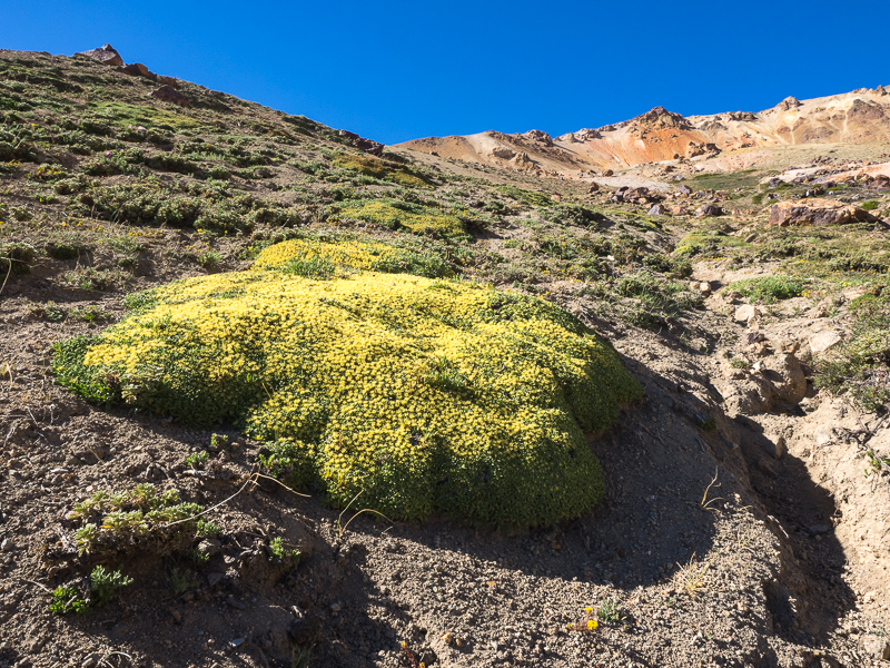 From now on the climbing is less steep. Often the trail traverses the ochre mountainsides. I only see some arrieros in the distance apart from that today there is no meeting with other people.  After another pass the landscape becomes rather wide and open. Fantastic walking with constantly superb views!  I have to circumnavigate and finally descent in three different valleys under a cloudless blue sky and here, at altitude, quite nice temperatures.  I suspect that higher up I find no water and wood, therefore I put up my camp already at 4.30 at 2940 m altitude.  I manage to find some small sticks, so I can light my woodstove and prepare dinner.  While I am eating, a condor circles in the sky not very high above me. Am I already really looking that dead? After dinner I start an evening walk to enjoy the very beautiful surroundings of my camp. There is even some animal life: Black ground squirrels make soil flying by their digging and some grey birds are not very shy.  
The birds are not shy
Under a steep brown- grey escarpment from which a thundering waterfall is deriving spread wonderful green pastures, followed by another steep cliff with emerald green grassland dotted by dozens of shimmering ponds at the foot.
     Back at the tent I am just in time to enjoy the sunset.   The night is quite cold, but although I carry only a 550 g down sleeping back, I get good sleep. Just after I start hiking next morning a Condor is landing on a rocky top, not too far away, so I can photograph the big bird for some time.  I climb a little more and get to a wide, barren Plateau.  The edge of a small stream is still frozen...  Later I reach a ridge which offers fantastic views, that I can follow for some time. Very good mountain hiking!   Then it is wide open space again. Although life most be very hard here at 3300 meters, some flowers dot the grey dust, and there are even horses, seemingly wild, roaming the vast plateau.    Before I have to descend steeply into a valley, the horse trail ends and I carry on cross country, which is quite easy in the open terrain. While I have my lunch break, I watch again a digging ground squirrel.  Quite surprisingly I get out of the mountain wilderness on an enormous road, which leads probably to a mine. Many switchbacks have set a heavy scar in the landscape, but at least the descent is quick and easy. Although there is this wide road, I see the whole day neither people nor cars.  Finally I reach the bridge over Rio Madero. I want to pitch my camp away from the road, but soon must realize, that I don't get much further. The climbing on the steep banks, baked mud with stones, is just too dangerous... Here in the river valley at 700 meters it is very hot, and my skin, from the german winter not used to extreme sun, starts to burn, so I better seek shade between some rocks. It is strange, in the morning I saw Condors, but here there are large parrots flying in flocks to trees on the other river side, a reminder of the tropics... This night I sleep under the blanket of a million southern stars, very good!  When I wake up in the morning, a lot of parrots are flying above me, to trees and rocks on the other side of Rio Madero. 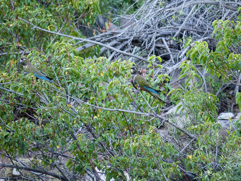   For some hours I follow the dirt road upwards. Like yesterday I don't see any other person. When I see a sign just before El Teniente mine, it is clear, that without permission this is off limits, even for hikers...  El Teniente is the largest copper mine in the world and I am quite happy, that I meet nobody... Soon I have passed the artificial lake with its salty crust and move inland away from the road. While I walk upwards I get good views on the enormous open pit mine. 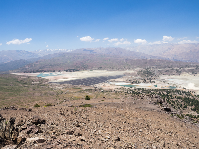 On the road I crossed some streams but didn't dare to fetch water, because I feared pollution from the mine. Therefore I only have two litres from Rio Madero left. That's a pity because on the ridgeline I will follow now for long time, there is no water at all... Sometimes a faint track is visible but often I walk cross country. It is nice to walk high above the valleys, but as there are many tops, which sometimes needs to be circumnavigated, my speed is not too high.   At one of the rare flat places I pitch my tent. The road to El Teniente deep in the valley below is not too far away, otherwise this would be a nice wild camping spot.  With the morning muesli I consume my last 0,5 litre bottle water. I enjoy a beautiful sunrise and soon after I am on the move again.  For a short stretch to a radio tower I follow a dirt track apart of that it is again tracks on the ridge.  The thorny vegetation is quite thick, but mostly I find stretches of bare ground. Only when I need to descent to the road, there is some serious bushwacking, but luckily only for a short stretch.  For some kilometres I walk on the tarmac but then somebody gives me a lift for about 4 km to Coya. Coya is a nice little former mining town. I meet a guy who speaks good english and offers to help me look for accomodation. But all we can find is an overpriced private room at about 70 Euro! At a small shop I gulp down water, orange juice and ice cream, before I buy supplies for the next stage.  I had planned to follow Rio Cipreses but soon I am at a massive gate and fence. The river is used for hydropower, probably that is the reason that there is no entry. Quickly I decide to stay on Jan's tracks and continue towards the Termas de Cauquenes.  Hiking under the hot sun in the broad Valley of Rio Cachapoal is not very interesting, but finally I get above a whitewater canyon.  I cross a steep sidestream on an almost rotten, wooden aqueduct and almost immediately get into another world: A shady park with large broadleaf trees and some well dressed people promenading! Soon I reach the large hotel complex of the Termas de Cauquenes which was build around a hot spring. It reminds me in a way of a monastery and seems to be quite old. I check in the cheapest room and enjoy shower and WiFi, followed by an exquisite dinner. Heaven for a hungry hiker, subsisting on muesli and spaghetti... |
Amazing
AntwortenLöschen